


The press release is a joint effort of the National Land Survey of Finland, University of Jyväskylä, VTT Technical Research Centre of Finland and Natural Resource Institute Finland.
Drone project prepares ground for new business with Tekes funding
The DroneKnowledge project received significant Challenge Finland funding from Tekes, the Finnish Funding Agency for Innovation, with the help of which the research and business involving drones, or flying robots, are expected to take great steps in development.
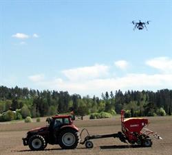
Remote sensing performed by drones, that is unmanned flying devices, is a new revolutionary technology for precise and efficient production of spatial data. Targets of application in practice are, for example, targeted fertilisation or identification of vermin in agriculture, water quality measurements, forest inventory measurements and built environment measurements. Measurements can be performed with cameras, laser scanners or spectral cameras.
Automatic acquisition of data in real time
The DroneKnowledge project aims to improve the entire remote sensing process: equipment, applications and data processing. Researchers aim at an automatic process in real time, so that the results collected by drones could be accessible during the flight or after the drone has landed.
– The data from the drone could go automatically to the tractor − even a self-driving tractor without a driver, says the project leader, Research Manager Eija Honkavaara from the National Land Survey of Finland.
More affordable spectral camera being developed
− In the project, we are developing a spectral camera which would be closer to the prices of consumer products, says Researcher Heikki Saari from the VTT Technical Research Centre of Finland.
There are targets of application for small spectral cameras for instance within water quality control, identification of tree species and precision agriculture.
− With a spectral camera, we can, for instance, optimise fertilisation or evaluate the best time for harvesting grass, states Researcher Jere Kaivosoja from the Natural Resources Institute Finland.
Research project with strong bonds to the corporate world
DroneKnowledge is a joint development project between the National Land Survey of Finland, University of Jyväskylä, Natural Resource Institute Finland and VTT Technical Research Centre of Finland. Well over a dozen enterprises that wish to utilise the research results in their business also participate in the project.
The goal is to transfer the methods developed into practice through the enterprises and present the drone know-how of Finnish research institutes and businesses.
− In October, we will organise an international workshop in Jyväskylä, where researchers and businesses have the opportunity to show their know-how to the international top within the field, says Docent Ilkka Pölönen from the University of Jyväskylä.
Caption: In future, drones will guide the work of tractors. Photo: Jere Kaivosoja.


